

This is the blog version of a project I did in cooperation with the Imabari Expatriate Office (ICIEA).
The Shikoku no Michi ‘Shikoku Road’ pilgrimage is a 1200 year old, 1200 kilometer route circling the island of Shikoku, Japan. 88 Buddhist temples mark the waystations of the journey. Although temple number one, Ryozen-ji, is in Tokushima, pilgrims can start anywhere. To complete the pilgrimage they must proceed until they return to their first temple. It is also known colloquially as the ‘Hachi-jiu hachi’ or ‘88’.

The pilgrimage was created at the time of Kukai, or Kobo Daishi, the Buddhist saint from Shikoku who is credited with bringing Buddhism to Japan, along with creating the Hiragana script (!). He lived in the late 7th and 8th centuries, during the Heian era. After a trip to China, he returned and became an itinerant monk. Most of the temples date from this time…
Pilgrims, if they walk in ordinal sequence, proceed south and west, clockwise from Tokushima’s temple #1 around the perimeter of Shikoku. It may be done by automobile, bus, motorcycle, bicycle, hitchhiking or walking. Walking, the slowest method, takes about forty-five days to complete the circuit.
Imabari contains six of the 88 temples. Visitors wishing to get a brief glimpse of the life of a ‘henro’ or pilgrim, can experience it in two days by walking this route. This guide will walk them in order, from Enmei-ji to Kokobun-ji. The total distance on paper is approximately 19 kilometers: if starting reasonably early, they could probably be done in one day. Note that all the temples close at 5pm however; you won’t be able to get your nokyocho signed after that time.
Taisan-ji and Senyu-ji offer reasonable accomodation. Please note that you will probably be expected to rise early for morning prayers!
 You’ll also need a few accessories: not required but the norm…such as a sedge henro hat, vest, walking stick and a blank book called Nokyocho, for obtaining calligraphic certifications from the priests at each temple. Temple #54, Enmei-ji, sells some henro accessories including route mapbooks in Japanese. There is a pilgrimage supply store as well, an hour west in downtown Matsuyama, beside the entrance to the arcade near Mizoguchi department store, and temple number one in Tokushima sells all the stuff. I bought the very cool English ‘Shikoku Japan 88 Route Guide’ at the store in Matsuyama for 1524 yen (C$15).
 Henro, upon arrival at a temple, enter, go to the hongan (main temple), pray (the heart sutra is the minimum), then pray at Kobo Daishi’s temple, after which they may seek out the priest’s office to receive the unique calligraphic stamp signifying that they have been there…it costs 300 yen (C$3).
You will probably meet other arukihenro (walking pilgrims) on the road or at the temples. Walking henro are not the most numerous pilgrims – you’ll also see large crowds of henro traveling by tourbus, and many do the pilgrimage by car. You may be stopped on the street and offered ‘o-settai’, money or gifts. You may not refuse them. They are gifts which the givers hope will bring blessings to themselves by helping you complete your journey.

I decided to walk the six local temples as a way of introducing myself to the pilgrimage proper. I hope to walk the entire pilgrimage later this year.
I took the local train three stops west to Onishi to start walking. The distance walked from Enmei-ji to Kokobun-ji is only about 20 km. so I felt I should lengthen the walk a bit. Walking from Onishi station adds about 4 kilometers to the tour. Of course I slept in, procrastinated and shallied about until at 10am I found myself at the train station, hoping to catch the 10:08 local west. Unfortunately there is no 10:08 local going west. And the Shio kaze (Sea Breeze) semi express trains don’t stop in Onishi. I counted three locals going east while I waited till 11:05 to catch the train going west. If you can’t check schedules, be prepared to do some creative lounging.

So I started walking at Onishi station at 11:20 or so. Most henro start walking around 7 in the morning: it’s the only way to cover 40km., with temple visits, by 5pm. This is the average distance required to complete the journey in 45 days or so. I had only a light pack with me.

Carrying rain gear is recommended, and a sweater if you’re walking in the winter. The weather is changeable in Imabari, though usually sunny, and in winter tends to be quite windy. Rain squalls are common then as well. June is the rainy season and a bad time to walk, unless you like being utterly drenched.
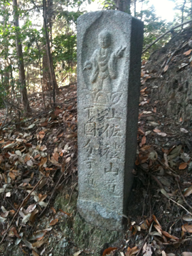
 I got to Enmeiji in about an hour; there is English signage on the roads to the temples. There will only be a few of these. However, there are also the traditional stone plinths with the pointing hand on them: these are the old henro route markers.

As well, you'll find kanji markers stuck to road signs along the routes. Sometimes you will see the Henro symbol, a stick figure of a walking man with a walking stick and sedge hat; these are also route markers. This is somewhat important as the henro routes often split, traverse neighborhoods and unmarked old roads etcetera. This pilgrimage is about wayfaring!


Walking through this semi rural area, I saw a Shikoku Garden Shed: an abandoned car used for storing garden stuff.
After leaving Enmei-ji, my route took me away from the busy, narrow 196 through Noma, to neighborhood roads and up onto a local mountain containing a large cemetery. At the height of land I found a pyramid of o jiso-sama statues.
 My friend Chiomi told me that these are abandoned gravestones.
 Having walked through the cemetery I came upon this small building, from the Meiji (1868 – 1912) or early Showa (1912 – 1945) eras.

An interesting example of European influenced architecture. I have no idea what it was for (it’s tiny), though it was probably a mausoleum (with windows!). There is also a large war memorial at the south end of the cemetery. Two blocks further along, tucked around the corner on the mountain, was the temple associated with the cemetery.
I stopped at a convenience store and bought some bento for lunch. I ate it in a local park, while being stared at by two soccer playing boys and a few passing obachans.
 Temple #55, Nanko-bo, was moved here in 714 (!) from Oyamazumi jinja on Omishima, fourth in the chain of islands that run north through the Seto Sea to Honshu. The temple is associated with a large jinja by the same name next door; Buddhist worshippers can enter by the large gate or ‘mon’ south of the torii entrance.
 Torii, the large, rectangular arches, always mark entrances to Shinto shrines; Buddhist temples are marked by gates which are building like structures which pilgrims walk through…often with large, somewhat fearsome statues of warrior deities on either side of the entrance.
Nanko-bo was burned in the bombing of Imabari in 1945, but rebuilt after the war. The very nice priest there gave me a Xerox map, in Japanese, which clearly shows all six temples, and the next five, in Saijo, as well.

By this time it was 2pm or so. The walk to Taisan-ji runs through Imabari’s neighborhood streets. Taisan-ji is a large temple with some intriguing smaller shrines. The hongan has nice shoji in the single (one large piece of glass) style, rather than the wood lattice and small pane style. Outside the temple, at the parking lot, I took this picture of a wonderful collection of jiso statues.
 O jiso-sama is the Buddha who takes care of travellers and children, and can be seen everywhere, often to mark the place someone has died. They are recognizable by the usually round, cherubic style of representation, and the handmade bibs and hats they sport, made by local grannies.
 The walk to temple Eifuku-ji, number 57, is a bit complicated. It is tucked into the mountainside about 3 km. south and west of Taisan-ji. I used a small path (marked) along the edge of the mountain at one point…the temple is very pretty, and has some henro accessories for sale.

Outside, on the street, a car rolled up and stopped. In it was a young man with his granddad. He asked me if I was a henro, and when I said yes, immediately offered me 300 yen o-settai! I was about to refuse, when I remembered I couldn’t...After a somewhat lengthy explanation on my part, he told me he had completed the walk last year and wished me luck. This is so cheering!
However it was 4:30 or so, starting to get dark now, and I decided to attempt Senyuji (3km…). I turned left, at the first corner. At this point I did not know that the temples all close at 5pm…
The roads to and from Senyujji were the most interesting on offer.

The street I walked up, quiet, residential, shady, soon turned into a small road, then a path. Within two hundred meters I was standing at the edge of a chicken farm and the footpath wound away. At a small bridge over a drainage ditch, looking up the mountain, the path disappeared into woods. The old path!

I had been hoping to find a section of the original, or older, or at least unpaved path. Here it was. The next kilometer or so made the day’s walking more than worthwhile.


The path winds through the woods up the mountain, occasionally crossing the paved road that leads up to Senyuji. The pilgrim can of course walk up the road…but this is so much more peaceful and lovely.
O-jiso sama dot the margins of the path, in places worn three feet deep into the volcanic soil by the feet of pilgrims. They mark the spot where someone died, and serve to remind the walker of those who came before.There are lots of them. It was a wonderful experience to be walking up the mountain in their company.
It was already getting hard to see when I came back out again onto the main road. Continuing up the road, I reached the garden and resting place just below the main mon. It was almost dark at this point, but I decided to walk through the mon and take the stairs the remaining distance up to the temple. I climbed them in the dark, and was thankful for the railings provided. A false step and I could have ended up in the creek!

An erasure, encountered in Imabari.
The temple was almost completely dark, only a few lights burning. A young priest was sweeping up the hongan, the doors almost closed. When I bid her good evening, she replied in English. ‘The temples all close at five, you know.’ I apologized and asked her to sign my nokyocho. She rolled her eyes (!), hesitated, then, finally, agreed to do so.
‘Are you staying here tonight? No? Well, you’d better take the road back down…’ I thanked her and headed back down the road. It was pitch dark.
Of course I got lost, and ended up going the wrong way, walking towards Sakurai. The moon was lovely, enormous, full, orange. It was cold.
As soon as I could, I turned left and made my way back north and east until I recognized the neighborhood near Taisan-ji. Then I limped back to the station, picked up my bike and pedaled home.
Two days later, I came back to finish the walk from Senyuji to Kokobun-ji, temple number 59. This guide would assume the walker to have made reservations at Taisan-ji or Senyuji and stay there overnight. However I live in the north of Imabari, near Chikamiyama, which is 7 km. or so from Senyuji. So I decided to ride my bike to the Tonda river, where I had seen arukihenro stone markers and knew the path wound along the river a ways. I left my bike locked to a sign and walked west and north towards Senyuji.
The distance between them is a little over six and a half kilometers. I soon found the corner where I’d turned the night before, but took a different route, hoping to find more forest path. And I did, about two kilometers. Using my ‘88’ English guidebook, I walked through neighborhoods until I came to a small shrine set up on a hill. A road wound up towards it. I decided to take it, and followed it past the shrine, a few fields, to where turned left into the woods.


Straight ahead of me I found a path with an arukihenro marker on it.I took it but this section of trail proved to be rutted, washed out and badly in need of repair. It was the only such section I found.
About 200 meters along, I came to a fork. I turned left, upward, and the path continued through pine and leafy wood, climbing and traversing along the mountain.
Occasionally views opened up of Imabari.
 Following one short but steep section, on the saddle of a ridge, I found two stone torii lanterns, and a signpost.The sign relates the story of Gorobei, a fisherman from Sakurai, who, hearing the large drum at Senyuji and believing it to scare off the fish, came up and slashed the drum, also casting insults at the Buddha. On his way back down the mountain he fell down this section of the trail, and hurt his back so badly he died. He is immortalized at this place for his troubles.
The trail carries on from this spot for another few hundred meters, after which it comes out at the garden below the main mon. I had missed this the night before in the dark…

Retracing my steps up the mountain, I rang the large bell this time, before leaving.

There is a very nice view of Imabari from the road right in front of the temple.
I returned back down the path, curious about the fork.
 I took the left turning route this time, and found a much better maintained path, leading further down the ridge, through a nice bamboo forest, exiting about fifty meters north of the same jinja I had turned at earlier. The road took an abrupt right hand turn on my left, so I went this way.
 I found myself wandering through the more rural edge of the city. Western Sakurai is full of big old farmhouses.

I found a beautiful abandoned house along the way.
As I was walking, I passed some greenhouses at the side of the road. Glancing inside I saw row upon row of low, leafy green plants. A farmer was harvesting something from them. I waved a good day and simultaneously saw a small flash of red: strawberries! This was on the 4th of January.
 The route is not so well marked or obvious here, though, so there is a bit of wayfaring to do to keep more or less on target to get to Kokobun-ji. There doesn’t seem to be one route: I found signs, put up at different times, on what were clearly different routes.
However if one aims for the Tondagawa, the path runs east along the river for perhaps a kilometer or so. Then the walker can turn right (south) along a busy street, cut through some neighborhoods east of this road, and walk southerly to Kokobunji. This is what I did. So the experience of getting lost, of wayfinding, is central to the pilgrimage, though efforts have been made to post routes.
Along the roads, I found a kofun site, a burial mound. There are over 3000 of these in Japan, dating from about 4000BC to about 700(?)AD; they were built by the Yayoi culture of ancient Japan. This one seems to be very recent and has a display of farm implements and straw boots and such.
 Across the road I saw an old minka or farmhouse, with a tin roof. The roof has suspiciously deep eaves, leading me to suspect it may cover the original thatch roof. This is a common site in rural Japan, as the cost of re-thatching, (which used to be a local skill, and practiced communally) has become prohibitive to almost everyone.
Kokobunji is the designated provincial (Ehime) temple. It’s been sitting on a small hill since 741, and, like all the temples is quite beautiful. It sports a life size stone statue of Kobo Daishi with his hand extended: you can shake his hand! So I did.

That was the end of my six temple walk. The determined hiker can continue to the next temple, number sixty, Yokomine-ji, - but it’s a twenty seven kilometer stroll!
I highly recommend this hike. It offers unique views of Imabari and Shikoku life not seen on tours or at the usual organized tourist sites. The best times to walk are from September to November, and March to May. The summer is very hot and humid, sometimes with heavy rain, the winters cool and windy with occasional storms. You’ll find snow inland.

Some useful numbers:
Lodging:
Ask for henro accommodation (shukubo).
Senyu-ji 0898-55-2141
Taisan-ji 0898-22-5959
Shikoku no michu websites:
Shikoku Henro Trail
Echoes of Incense
Guidebooks:
Shikoku Japan 88 Route Guide by Tateki Miyazaki, pub. Buyodo Co., Ltd. (2007)
ISBN 978-4-8297-1054-8
I can’t recommend this book highly enough: not only does it have maps with train stations marked, it also has lots of information about the pilgrimage, including phone numbers for all the temples and distances between them. An invaluable resource for the English speaking pilgrim.
There is also a two volume map book of the pilgrimage available at Ryozen-ji, the bookstore in Matsuyama I mentioned earlier, and at Enmei-ji in Imabari. It may be available at other temples as well. It’s in Japanese.
A Henro Pilgrimage Guide to the 88 Temples of Shikoku Island, Japan
By Bishop Taisen Miyata (Koyasan Buddhist Temple, Los Angeles, USA) (2006)
I haven’t seen this book: apparently it’s available at temple number one, Ryozenji, in Tokushima, as well as from the author, in Los Angeles.
Japanese Pilgrimage by Oliver Statler (1983)
My copy was located second hand, but it looks like it's back in print. A lovely, semi-fictionalized account of the pilgrimage. Statler walked the route four times.
Arukihenro, an ethnographic documentary by Tommi Mendel and Atsuka Toda. It's great!